Polychaeta taxon details
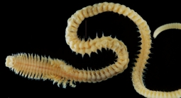
Dendronereis chipolini Hsueh, 2019
1366016 (urn:lsid:marinespecies.org:taxname:1366016)
accepted
Species
marine, brackish, fresh, terrestrial
recent only
Hsueh, Pan-Wen. (2019). Two new species of nereidids (Annelida, Polychaeta) from Taiwan. <em>Zootaxa.</em> 4652(3): 544-556., available online at https://www.mapress.com/j/zt/article/view/zootaxa.4652.3.10 [details] Available for editors  [request]
Holotype NMNS 7861-001, geounit Taiwanese part of the...
, Note Brackish aquaculture ponds nearby the mouth of...
Holotype NMNS 7861-001, geounit Taiwanese part of the Eastern China Sea [details]
From editor or global species database
Type locality Brackish aquaculture ponds nearby the mouth of Kaoping River, southern Taiwan, 22.4787, 120.4322 (22°28.72´N 120°25.93´E), sandy mud bottom [details]
Etymology Author: the name Dendronereis chipolini is "dedicated to the memory of Mr. Chi Po-Lin (27 December 1964–10 June 2017)...
Etymology Author: the name Dendronereis chipolini is "dedicated to the memory of Mr. Chi Po-Lin (27 December 1964–10 June 2017) aerial photographer and documentary film director ..." [details]
Read, G.; Fauchald, K. (Ed.) (2025). World Polychaeta Database. Dendronereis chipolini Hsueh, 2019. Accessed at: https://www.marinespecies.org/polychaeta/aphia.php?p=taxdetails&id=1366016 on 2025-05-09
Date
action
by
original description
Hsueh, Pan-Wen. (2019). Two new species of nereidids (Annelida, Polychaeta) from Taiwan. <em>Zootaxa.</em> 4652(3): 544-556., available online at https://www.mapress.com/j/zt/article/view/zootaxa.4652.3.10 [details] Available for editors  [request]
 Present
  Inaccurate
  Introduced: alien
  Containing type locality
Holotype NMNS 7861-001, geounit Taiwanese part of the Eastern China Sea [details]
From editor or global species database
Etymology Author: the name Dendronereis chipolini is "dedicated to the memory of Mr. Chi Po-Lin (27 December 1964–10 June 2017) aerial photographer and documentary film director ..." [details]Type locality Brackish aquaculture ponds nearby the mouth of Kaoping River, southern Taiwan, 22.4787, 120.4322 (22°28.72´N 120°25.93´E), sandy mud bottom [details]

