Difference between revisions of "Guria Coastal Region"
| Line 24: | Line 24: | ||
- Habitat loss | - Habitat loss | ||
| + | |||
<u>Relation between the Coastal issue and the ICZM protocol principles and articles.</u> | <u>Relation between the Coastal issue and the ICZM protocol principles and articles.</u> | ||
Revision as of 16:39, 19 July 2012
CASE description
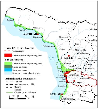
Guria Coastal Region is located along the Black Sea coast of Georgia, spreading approx. 21.5 km from River Natanebi to the southern edge of the city of Poti. Two main landscape types are the coastal plains, dominated by agriculture, which are characterised by flat, open landscapes with distant views of the Caucasus Mountains, and foothills of the Lesser Caucasus. In the area from River Natanebi to River Supsa is present an important cluster of tourism activities (Ureki resort with its black sand beaches). Within this area, the British Petroleum controls Supsa oil terminal with 4 x 40,000 m3 storage capacity. Construction of a new Supsa port and related infrastructure was recently approved in the same area. The coastal substrata here is comprised of coarse to fine sands. The coastline just south of Poti is relatively undeveloped, while Grigoleti and Shekvetili settlements contain uncontrolled dacha (summer house) developments.
ICZM phase
Main coastal issues
- Bathing water quality and beach litter
- Weak quality of EIA process in coastal development projects, such as new Supsa port
- Inadequate erosion control
- Habitat loss
Relation between the Coastal issue and the ICZM protocol principles and articles.
Article 15. Awareness-raising, Training, Education and Research – regional and local level training in various aspects of ICZM such as application of indicators tool.
Article 16. Monitoring and Observation Mechanisms and Networks – applying coastal inventories and indicators at the regional level. Developing web-based node for spatial information dissemination (Tskaltsminda GIS system).
Article 18. National Coastal Strategies, Plans and Programmes – monitoring the performance of the local ICZM plan developed earlier (Tskaltsminda pilot project).
Article 19. Environmental Assessment – introduction of EU compatible guidelines for EIA/SEA for application in the coastal zone. Monitoring the quality of EIA for the coastal development projects.
Article 22. Natural Hazards – assessing coastal erosion (utilising hydrological modelling).
Article 27. Exchange of Information and Activities of Common Interest – defining coastal management indicators and cooperating with stakeholders in the use of such indicators; implementing demonstration ICZM projects such as CASES.
Relevance of the coastal issue
Indicators have not been applied yet in the CASE, therefore the following conclusions are based on expert judgement. There have been no improvements in bathing water quality or beach litter management. EIA regulations and quality of EIAs for coastal development projects remain weak. Supsa Port EIA is a good example – low quality of EIA was approved, and as was recently reported in the national media, initiated works resulted in destruction of coastal habitat (natural wetland), but construction is now halted probably due to lack of financing. In addition, dozens of local households were resettled from their lands. Positive factor of halt in construction is that expected coastal erosion risk was not enhanced further.
Objectives
- Development of coastal management tools
- Improvement of erosion control and watershed management
End Products
Application of ICZM indicators - SDI - Change detection
Tools foreseen to be developed and used
Indicators - LEAC - Participatory methods - SDI
Other tools to be applied
EIA - Remote sensing - Watershed modelling
Training needs
Indicators - LEAC - Participatory methods
CASE Responsibles
Mamuka Gvilava - Black Sea Commission Permanent Secretariat (BSC PS) - email: MGvilava@ICZM.ge
Amiran Gigineishvili - Georgia CASE Coordinator - email: lanchkhuti@civitas.ge
Elaboration: Stefano Soriani, Fabrizia Buono, Monica Camuffo, Marco Tonino, University Ca’ Foscari of Venice.


