PEGASO CASES
From MarineSpecies Traits Wiki
Introduction
10 PEGASO CASES (Collaborative Application SitES) aim at testing and validating the assessment tools developed during the project at different spatial scales, and at contributing to the Regional Assessment at basin scale of the Mediterranean and Black Sea. The CASES have been chosen in order to obtain a set of heterogeneous coastal situations; the CASES selected both in the Mediterranean (7 CASES) and in the Black Sea (3 CASES) represent different coastal physical features, geographic scales, socio economic contexts, coastal issues, conflicts among uses, and ICZM experiences. The CASES, shown in the list below, represent valuable coastal ecosystems (e.g. river deltas, lagoons, protected areas), they range from a local scale of few kilometers to a transboundary scale of thousands kilometers; some of the CASES have already gained experiences in the field of ICZM while others have started considering ICZM only recently; some CASES show coastal issues concerned with natural hazards (e.g. erosion, sea level rise inundation), other with anthropogenic impacts (e.g. urban sprawl, pollution) and different conflicts among land uses.
The PEGASO project is indeed a challenge for researchers and practitioners: given the great heterogeneity of the CASES, great attention will be paid on the efforts for addressing flexibility and effectiveness of the assessment tools.
Below you can find specific information for each CASE by clicking on the flags in the map (left) or on the names (right). The information is structured as follows:
Some general information on the CASE. As stated before, the 10 PEGASO CASES have different scales, coastal issues and ICZM experience.
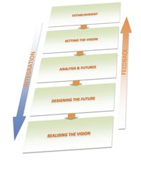 ICZM Phases
Identification of the starting phase for the specific CASE (based on the checklist on ICZM phase).
List of the main coastal issues selected for the CASE. Coastal Issues could be relevant both at national and basin scale.
It specifies the objectives applicable to each CASE (e.g. to develop planning options for decision-makers, to increase the well-being of fishermen, to develop adaptation strategy for climate change) on the basis of the selected coastal issues.
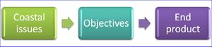 Relation between coastal issues, objectives and end products List of the end-product(s) produced or achieved for each specific objective (e.g. Early warning system, project proposals for new funding, National ICZM strategy, Decision Support System Tool, new institutional proposals).
- Tools foreseen to be developed and used
Identification of the PEGASO tools to be applied: LEAC, participatory methods, scenario, indicators, socio-economic assessment.
Other tools may be developed/implemented.
Training needs about PEGASO tools are stated based on CASES requirements.
10 PEGASO CASES - Overview
Loading map... {"minzoom":false,"maxzoom":false,"mappingservice":"leaflet","width":"500px","height":"350px","centre":false,"title":"","label":"","icon":"","lines":[],"polygons":[],"circles":[],"rectangles":[],"copycoords":false,"static":false,"zoom":false,"defzoom":14,"layers":["OpenStreetMap"],"image layers":[],"overlays":[],"resizable":false,"fullscreen":false,"scrollwheelzoom":true,"cluster":false,"clustermaxzoom":20,"clusterzoomonclick":true,"clustermaxradius":80,"clusterspiderfy":true,"geojson":"","clicktarget":"","imageLayers":[],"locations":[{"text":"\u003Cdiv class=\"mw-parser-output\"\u003E\u003Cp\u003E\u003Ca href=\"/r/index.php?title=North_Adriatic_Sea\u0026amp;action=edit\u0026amp;redlink=1\" class=\"new\" title=\"North Adriatic Sea (page does not exist)\"\u003ENorth Adriatic Sea\u003C/a\u003E\n\u003C/p\u003E\u003C/div\u003E","title":"North Adriatic Sea\n","link":"","lat":45.27,"lon":12.95,"icon":""},{"text":"\u003Cdiv class=\"mw-parser-output\"\u003E\u003Cp\u003E\u003Ca href=\"/traits/wiki/Aegean_Islands\" title=\"Aegean Islands\"\u003EAegean Islands\u003C/a\u003E\n\u003C/p\u003E\u003C/div\u003E","title":"Aegean Islands\n","link":"","lat":37.58,"lon":26.06,"icon":""},{"text":"\u003Cdiv class=\"mw-parser-output\"\u003E\u003Cp\u003E\u003Ca href=\"/traits/wiki/Al_Hoceima_coast\" title=\"Al Hoceima coast\"\u003EAl Hoceima coast\u003C/a\u003E\n\u003C/p\u003E\u003C/div\u003E","title":"Al Hoceima coast\n","link":"","lat":35.28,"lon":-3.85,"icon":""},{"text":"\u003Cdiv class=\"mw-parser-output\"\u003E\u003Cp\u003E\u003Ca href=\"/traits/wiki/North_Lebanon_Coastal_Zone\" title=\"North Lebanon Coastal Zone\"\u003ENorth Lebanon Coastal Zone\u003C/a\u003E\n\u003C/p\u003E\u003C/div\u003E","title":"North Lebanon Coastal Zone\n","link":"","lat":34.53,"lon":35.95,"icon":""},{"text":"\u003Cdiv class=\"mw-parser-output\"\u003E\u003Cp\u003E\u003Ca href=\"/traits/wiki/Bouches_du_Rhone\" title=\"Bouches du Rhone\"\u003EBouches du Rhone\u003C/a\u003E\n\u003C/p\u003E\u003C/div\u003E","title":"Bouches du Rhone\n","link":"","lat":43.5,"lon":5,"icon":""},{"text":"\u003Cdiv class=\"mw-parser-output\"\u003E\u003Cp\u003E\u003Ca href=\"/traits/wiki/Sevastopol_Bay\" title=\"Sevastopol Bay\"\u003ESevastopol Bay\u003C/a\u003E\n\u003C/p\u003E\u003C/div\u003E","title":"Sevastopol Bay\n","link":"","lat":44.6167,"lon":33.55,"icon":""},{"text":"\u003Cdiv class=\"mw-parser-output\"\u003E\u003Cp\u003E\u003Ca href=\"/traits/wiki/Danube_Delta\" title=\"Danube Delta\"\u003EDanube Delta\u003C/a\u003E\n\u003C/p\u003E\u003C/div\u003E","title":"Danube Delta\n","link":"","lat":45.5,"lon":29.4167,"icon":""},{"text":"\u003Cdiv class=\"mw-parser-output\"\u003E\u003Cp\u003E\u003Ca href=\"/traits/wiki/Nile_Delta\" title=\"Nile Delta\"\u003ENile Delta\u003C/a\u003E\n\u003C/p\u003E\u003C/div\u003E","title":"Nile Delta\n","link":"","lat":30.9578,"lon":31.0222,"icon":""},{"text":"\u003Cdiv class=\"mw-parser-output\"\u003E\u003Cp\u003E\u003Ca href=\"/traits/wiki/Dalyan-Koycegiz_Special_Protected_Area\" title=\"Dalyan-Koycegiz Special Protected Area\"\u003EDalyan-Koycegiz Special Protected Area\u003C/a\u003E\n\u003C/p\u003E\u003C/div\u003E","title":"Dalyan-Koycegiz Special Protected Area\n","link":"","lat":36.83294,"lon":28.6396,"icon":""},{"text":"\u003Cdiv class=\"mw-parser-output\"\u003E\u003Cp\u003E\u003Ca href=\"/traits/wiki/Guria_Coastal_Region\" title=\"Guria Coastal Region\"\u003EGuria Coastal Region\u003C/a\u003E\n\u003C/p\u003E\u003C/div\u003E","title":"Guria Coastal Region\n","link":"","lat":41.968,"lon":42.044,"icon":""}],"imageoverlays":null}
|
- Mediterranean Sea
- Black Sea
|
| |

 ICZM Phases