Talk:French case studies: Upper tidal flat evolution in the bay of Mont-Saint-Michel (NW France)
Review by Job Dronkers (January 2013)
The article describes nicely some aspects of tidal flat morphodynamics in the Baie du Mont Saint-Michel. Progradation and erosion of tidal flats is a higly dynamic process in the eastern part of the Baie, related to the divagations of the tidal channels of the Sée, Sélune and Couesnon rivers.
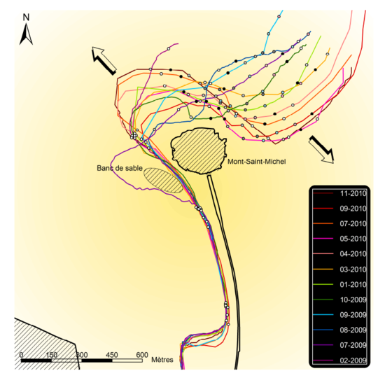
The strong divagation of the Couesnon at the Mont Saint-Michel in the period 2009-2010 is shown as an illustration in the opposite figure. It pictures the course of the Couesnon tidal channel around the Mont Saint-Michel (at the centre) at different times during the period 2009-2010 (taken from the thesis of Lucile Gluard, Université de Caen, 2012).
The fast rising tide with high flood velocities is probably a major cause of the overall net sedimentation of the Baie du Mont Saint-Michel. At high spring tides, a tidal bore propagates into the Baie, shown in the figure below (taken at sunset on the 1st of September 2011).
Since a few years, the tidal flat progradation around the Mont Saint-Michel is counteracted by artificial flushing. For this purpose, a mobile barrier has been built in the Couesnon river, which has become operational in 2009. The river behind the barrier is used as flushing reservoir, which is filled at high water and emptied at low water. In the coming years, the dyke between the Mont and the land will be removed and a second flushing channel will be dredged at the Eastern side of the Mont.
Figure 4 is unfortunately missing in the article. The English translation of Mont Saint-Michel creates confusion with the Saint Michael’s Mount in Cornwall, UK – a place which bears some resemblance to the Mont Saint-Michel.


